Earth Timelaps: consapevolezza del cambiamento climatico — Awareness about Climate change
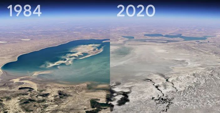
Il cambiamento climatico e gli effetti del riscaldamento globale sulla terra, la desertificazione, le alluvioni, le inondazioni sono complicati da comprendere. Si visualizzano attraverso mappe che rivelano geografie lontane e territori apparentemente in lento movimento. Google Earth ha messo a disposizione uno strumento straordinario per accrescere la consapevolezza della mutazione: con Timelapse in Google Earth, ora possiamo renderci conto degli utlimi quattro decenni di cambiamenti in tutto il pianeta. Quarant’anni, metà di una vita media, in cui abbiamo disequilibrato il pianeta. E così possiamo rendercene conto.
Climate change and the effects of global warming on earth, thus mainly desertification and floods are difficult to understand. Satellite maps reveal distant geographies and seemingly slow-moving territories. Google Earth has provided an extraordinary tool for raising awareness of the entity of the phenomenon: thanks to Timelapse feature in Google Earth, we can now see the past four decades of change across the country. In forty years, half of an average lifespan, in which we have unbalanced the planet. We can now realize it.
Timelaspse is a global zoomable video that lets you see how the Earth has changend over the past 30 years. It is made from 35 cloud-free annual mosaics, one for each year from 1984 to 2018, wich are made interactively explorable by Carnegie Mellon University CREATE Labs Time Machine Library, a technology for creating and viewing zooming and pannable timelapses over space and time.


")
")