Earth Timelaps: consapevolezza del cambiamento climatico — Awareness about Climate change
Il cambiamento climatico e gli effetti del riscaldamento globale sulla terra, la desertificazione, le alluvioni, le inondazioni sono complicati da comprendere. Si visualizzano attraverso mappe che rivelano geografie lontane e territori apparentemente in lento movimento. Google Earth ha messo a disposizione uno strumento straordinario per accrescere la consapevolezza della mutazione: con Timelapse in Google Earth, ora possiamo renderci conto degli utlimi quattro decenni di cambiamenti in tutto il pianeta. Quarant’anni, metà di una vita media, in cui abbiamo disequilibrato il pianeta. E così possiamo rendercene conto.
Climate change and the effects of global warming on earth, thus mainly desertification and floods are difficult to understand. Satellite maps reveal distant geographies and seemingly slow-moving territories. Google Earth has provided an extraordinary tool for raising awareness of the entity of the phenomenon: thanks to Timelapse feature in Google Earth, we can now see the past four decades of change across the country. In forty years, half of an average lifespan, in which we have unbalanced the planet. We can now realize it.
Timelaspse is a global zoomable video that lets you see how the Earth has changend over the past 30 years. It is made from 35 cloud-free annual mosaics, one for each year from 1984 to 2018, wich are made interactively explorable by Carnegie Mellon University CREATE Labs Time Machine Library, a technology for creating and viewing zooming and pannable timelapses over space and time.
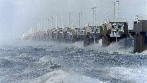
Oostersceldekering, la diga olandese — The Dutch Dam
Fa parte del Piano Delta, il più grande sistema di protezione dalle inondazioni in tutto il mondo. La Oostersceldekering è lunga circa 9 chilometri. Con un costo complessivo di 2,5 miliardi di euro si è riusciti a proteggere un territorio a rischio idrogeologico. È una struttura di lunghezza totale di lunga 25 km con pilastri alti 30 metri e con un peso totale di oltre 20000 tonnellate. Al raggiungimento del livello critico del mare le due paratoie, di lunghezza 210 metri e altezza 22 metri e costituite da 15000 tonnellate di acciaio, vengono sbarrate con l’ausilio di un sistema centralizzato. In ordine di grandezza, si posiziona al primo posto la diga dell’Oosterscheldekering della Schelda che è formata da 65 piloni e 62 paratie che vengono alzate quando il livello del mare raggiunge l’altezza critica.
After the disaster of 1953, work began on the largest flood protection system in the world. With the name of Piano Delta, Holland could boast of this disk consisting of three permanently closed structures, four barriers to face the storms and six dams. A structure of such enormous dimensions has never been built. The barrier consists of 65 pillars of 30 to 40 meters high and 62 sliders of 42 meters wide and 6 to 12 meters high. That makes the defense barrier (cost 2.5 billion euro) one of the most impressive hydraulic constructions in The Netherlands. The construction of the 9 kilometer long storm surge barrier the “Oosterscheldekering” is a complex and unique project.
A lot of discussion precedes the construction of the barrier. At first, the plan is to close off the Oosterschelde with a solid dam. However, fishermen and nature conservationists revolt against this plan. The Oosterschelde is a unique nature reserve with more than 70 species of fish, 140 species of aquatic plants and algae and 350 species of benthic animals, which live on the sea bed. Building a solid dam would result in this nature reserve suffering irreparable damage. Completely closing off the sea arm means the end of the salt water environment in the Oosterschelde and therefore also the cultivation of mussels and oysters. The protest – with the Oosterschelde Open as battle cry – does not fall on deaf ears. In 1975, the then Cabinet came up with the proposal to build an open barrier that could be closed by means of gates – if necessary. A permeable barrier is much more expensive than a solid dam and thus the Cabinet’s proposal leads to fierce debates. In 1979 parliament approved the plan for the construction of the Oosterscheldekering.
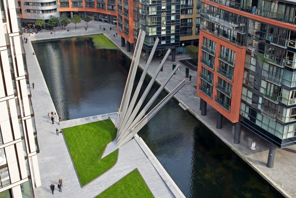
Il ponte mobile di Merchant Square a Londra— Merchant Square Footbridge in London
Knight Architects e AKT II per l’ingegneria strutturale hanno progettato il Merchant Square Footbridge, struttura a sbalzo larga tre metri che si estende per venti metri e attraversa il Grand Union Canal. Quando serve, viene sollevata utilizzando martinetti idraulici con un’azione simile a quella di un tradizionale ventilatore giapponese. Questo crea una scultura cinetica la cui silhouette è sia leggibile che straordinaria e che ben si adatta alla posizione accanto al canale. Le cinque travi di acciaio fabbricate che formano il ponte si aprono in sequenza, con il primo che sale ad un angolo di 70 gradi e l’ultimo raggiunge la distanza richiesta sul canale di 2,5 m di altezza per 5,5 m di larghezza a metà canale. I contrappesi sagomati aiutano il meccanismo idraulico e riducono l’energia necessaria per spostare la struttura (photo Edmund Sumner).
Knight Architects and structural engineers AKT II have designed the Merchant Square Footbridge, the 3m wide cantilevered structure spans 20m across the Grand Union Canal and is raised using hydraulic jacks with an action similar to that of a traditional Japanese hand fan. This creates a kinetic sculpture whose silhouette is both legible and extraordinary and which is well suited to the position next to the canal. The five fabricated steel beams forming the deck open in sequence, with the first rising to an angle of 70 degrees and the last achieving the required clearance over the canal of 2.5m tall by 5.5m wide at mid channel. Shaped counterweights assist the hydraulic mechanism and reduce the energy required to move the structure(p hoto Edmund Sumner).
Knights Architects: with a wealth of specialist design experience, the diverse team of experts is well-versed in bringing clarity, integrity and innovation to complex infrastructure projects. Their service is tailored and accessible, providing the unique blend of skills required for each project. They pride themselves on becoming an integral part of team, seeking to distil the political and cultural context of a project to deliver bespoke solutions that reflect the society they design for.
Goccia d’acqua … a forma di museo in Giappone— Water drop shaped … like a museum in Japan
Il Museo d’Arte di Teshima (2010) sorge su una collina sull’isola di Teshima e si affaccia sul mare interno di Seto. Il museo che ha la geometria di un agoccia d’acqua in appoggio, si trova nell’angolo di una terrazza di riso che è stata restaurata in collaborazione con i residenti locali. Strutturalmente, l’edificio è costituito da un guscio di cemento, privo di pilastri, che copre uno spazio di circa 40 per 60 metri e con un’altezza massima di 4,3 metri. Due aperture ovali nel guscio consentono al vento, ai suoni e alla luce del mondo esterno di entrare in questo spazio organico in cui natura e architettura si intrecciano. Nello spazio interno, l’acqua scorre continuamente dal terreno in un giorno di movimento.
Teshima Art Museum (2010) stands on a hill on the island of Teshima overlooking the Seto Inland Sea. The museum, which resembles a water droplet at the moment of landing, is located in the corner of a rice terrace that was restored in collaboration with local residents. Structurally, the building consists of a concrete shell, devoid of pillars, coving a space about 40 by 60 meters and with a maximum height of 4.3 meters. Two oval openings in the shell allow wind, sounds, and light of the world outside into this organic space where nature and architecture intimately interconnect. In the interior space, water continuously springs from the ground in a day long motion.
Ryue Nishizawa is born in Tokyo, 1966. Degree in M.A. (Architecture), Yokohama National University. Joined Kazuyo Sejima & Associates in 1990, established SANAA with her in 1995, established Office of Ryue Nishizawa in 1997. Professor at Yokohama Graduate School of Architecture. Recipient of international awards, including the Gold Lion at the 9th Venice Architecture Biennale, in 2004, and the Pritzker Prize in 2010. Significant Works: Weekend House (1998, Gunma), 21st Century Museum of Contemporary Art, Kanazawa* (2004, Ishikawa), Honmura Lounge & Archive (2004, Naoshima, Kagawa), Moriyama House (2002-05, Tokyo), Marine Station Naoshima, co-designed with Sejima Kazuyo (2006, Naoshima), Towada Art Center (2008, Aomori). The Teshima Art Museum was awarded the 25th Murano Togo Prize in 2011.
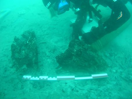
Una foresta del 6000 a. C. sotto il mare — 6000 b.C. forest under the sea
L’hanno scoperta gli scienziati del Centro di Ricerca archeologica subacquea della Linguadooca a circa un chilometro dalla costa di Palavas-les-Flots. È una foresta sommersa da 8000 anni. Ed è un bellissimo racconto in cui i protagonisti sono l’acqua e il tempo; non è legato al cambiamento climatico, ma è un’affascinante testimonianza dell’acqua come dimensione del tempo. La datazione al carbonio 14 è stata quindi utilizzata per stimare l’età della foresta: 6000 a.C. che, in effetti, coincide con il periodo in cui l’innalzamento del livello del mare è stato molto rapido. Esistono solo altre due altre foreste sottomarine nel mondo. La prima è stata scoperta al largo dell’Alabama (nel video), negli Stati Uniti, nel 2005, per effetto dell’uragano Katrina; la seconda, nel 2014, vicino al Galles. (Immagini tratte dal sito www.sciencesetavenir.fr)
Scientists from the Languedoc Underwater Archaeological Research Center discovered the forest about a kilometer from the coast of Palavas-les-Flots. It has been submerged for 8000 years. And it is a beautiful story whose protagonists are water and time; it is not linked to climate change, but it is a fascinating testimony of water as a dimension of time. Carbon 14 dating was then used to estimate the forest age: 6000 years B.C. which, in fact, coincides with the period when the sea level rise was very rapid. There are only two other underwater forests in the world. The first one was discovered off the coast of Alabama (see in the video), in the United States, in 2005, due to the effect of Hurricane Katrina; the second, in 2014, near Wales.
The carbon 14 dating carried out on these woody elements dated them to 6000 years B.C. The plants were identified as oaks by a xylological study. To date, only two other examples of drowned forests are known in the world. In Mobile, off the coast of Alabama (United States), revealed by Hurricane Katrina (in 2005) and dated 50,000 years ago; and in Wales, exposed by a storm, in 2014. These exceptional discoveries are direct indicators of the position of the palaeo-littoral as it was before the rise in sea level, during the Holocene, the geological period of the last 10,000 years. They constitute a proven marking of the localization of the coastline of the time.
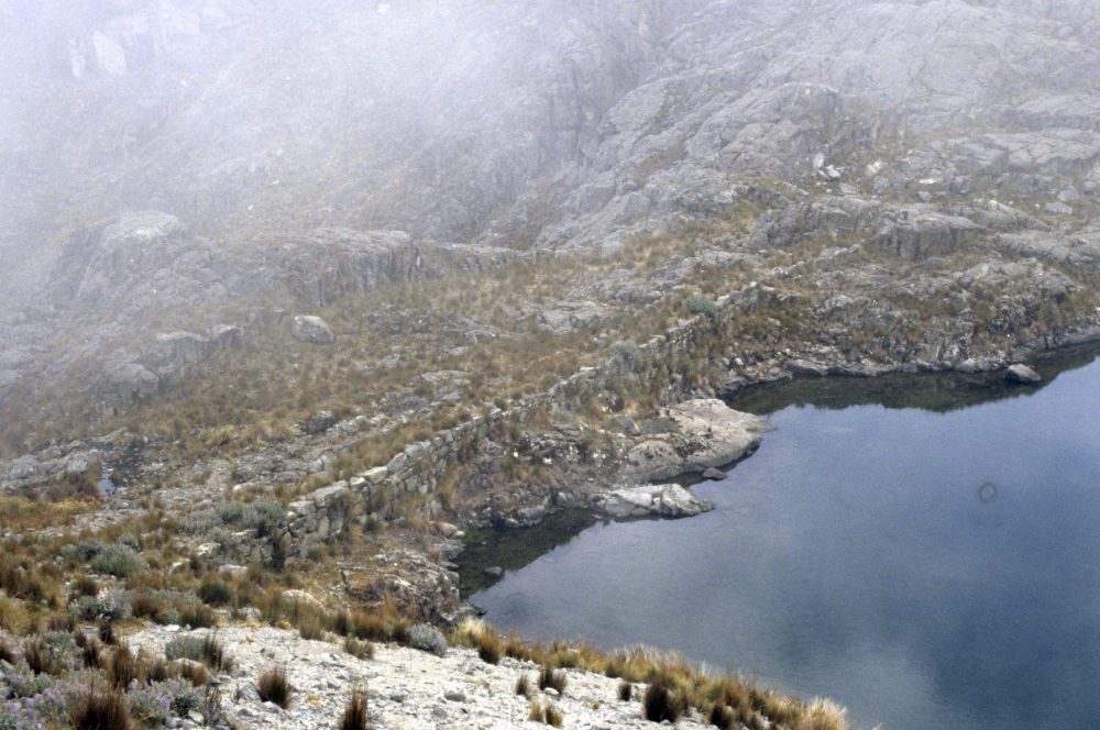
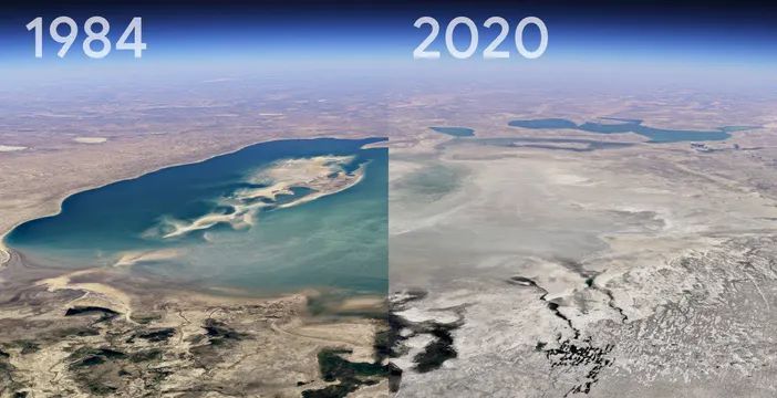
Si stanno sciogliendo i ghiacciai delle Ande — Glaciers in the Andes are melting
La superficie dei ghiacciai delle Ande si è ridotta del 25 per cento in poco più di vent’anni a causa del cambiamento climatico. Ne soffre l’agricoltura della Cordillera Blanca che nei mesi di siccità utilizza l’acqua dei ghiacciai per l’irrigazione e di conseguenza per le 250mila persone che abitano le montagne. Dopo l’insuccesso di un progetto idrico complesso, si sta provando a integrare le antiche dighe abbandonate sulla Cordillera Negra, dove non ci sono ghiacciai, con i sistemi idrici contemporanei. Le Ande sono la più grande catena montuosa nel mondo e provvedono al sostentamento di 160 milioni di persone in sette paesi.
The surface of the Andes glaciers has shrunk by 25 percent in just over twenty years due to climate change. This is causing significant suffering for the agriculture of the Cordillera Blanca which in the months of drought used the water of the glaciers for irrigation and consequently for the 250 thousand people who live in the mountains. A very complex water supply project did not work. Now they are trying to integrate the ancient abandoned dams on the Cordillera Negra, where there are no glaciers, with contemporary water systems. The Andes are the largest mountain range in the world and provide for the livelihood of 160 million people in seven countries.
Over the past few decades there has been an increasing interest in building micro-dams across the whole of the Cordillera Negra, North-Central Andes, Peru. Given the difficulties in maintaining a regular flow of water, especially during the dry season, it is a logical response to a pressing need. Indigenous skill and landscape knowhow informed the selection of sites for damming. Modern engineers have followed their lead, such that present-day micro-dams often occupy the same space as the prehispanic ones. Aside from the obvious destruction of cultural heritage – usually without a proper archaeological survey – there is one other problem with this policy: not all the old dams which are now being reconstructed were built for retaining just water. For more information read here
Video di città sommerse: ne abbiamo bisogno? — Flooded cities videos: do we need them?
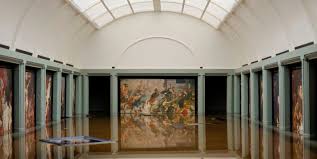
L’ultimo è stato proiettato all’Armory Show, una fiera d’arte contemporanea che si è appena conclusa (marzo 2020), a New York. È un video di Tezi Gabunia, un’artista georgiano, che fa vedere una sala del Louvre di Parigi che si riempie lentamente d’acqua fino a esserne quasi sommersa. L’acqua, segnale del cambiamento climatico, inascoltata, diventa tragedia e distruzione. Il cambiamento climatico non riguarda solo l’Antartide, i ghiacci che si sciolgono e i terreni riarsi nel sud del mondo. È qui e ora. La torre di Pisa, il Louvre a Parigi o Londra sommersi fanno crescere la nostra consapevolezza e mutano il nostro modo di fare architettura. Immagine in apertura e video dal sito www.ignant.com.
BREAKING NEWS: FLOODING OF THE LOUVRE Tezi Gabunia #ArmoryShow, TeziGabunia #tempodacqua #thetimeofwater
The last one has been shown in the contemporary art fair that has just ended (march 2020), at the Armory Show in New York. The video by Tezi Gabunia, a Georgian artist, shows a room in the Louvre in Paris that slowly fills with water until it is almost submerged. Water is a sentinel of climate change that, ignored, becomes tragedy and destruction. Climate change is not just about Antarctica, melting ice and parched land in the south of the world. It is here and now. The Tower of Pisa, Louvre in Paris or London city submerged increase our awareness and change the way we do architecture.
Global temperatures and sea levels are rising. Low-lying coastal cities are already experiencing devastating floods and working to come up with creative solutions to combat rising tides. Some cities are sinking due to increasing sea levels slowly encroaching on their coasts, while others are sinking because of excessive groundwater pumping that creates a change in pressure and volume that causes land to sink. Here are 11 sinking cities that are in danger of disappearing: Jakarta, Indonesia; Lagos, Nigeria; Houston, Texas, Dhaka, Bangladesh; Venice Italy, Virginia Beach, US; Bankok, Thailandia; New Orleans, US; Rotterdam, The Netherlands; Alwxandria, Egypt; Miami, US (for more information, click here)
.
Osservare l’acqua dallo spazio — Water Monitoring from Space
Si chiama WaMos Water Monitorin from Space e se ne occupa un’italiana, Elisa Fagiolini, che è CEO/CTO del progetto. In un’intervista concessa al centro di ricerca tedesco GFZ e ripresa da Perugia Today, Elisa ha spiegato che quando il ghiaccio sulla Groenlandia si scioglie, i ghiacciai perdono massa che scorre nel mare. Questo si può misurare dallo spazio, così come i serbatoi di acque sotterranee sotto la California sia quando stanno perdendo massa e anche quando il terreno è saturo d’acqua e quindi non può più assorbire la pioggia, aumentando il rischio di inondazioni. Con l’aiuto delle misurazioni dei campi gravitazionali, si possono prevedere sia la carenza d’acqua, sia le inondazioni.
WA.MO.S WATER MONITORING FROM SPACE Elisa Fagiolini #GZEHelmholtzCenterPotsdam #tempodacqua #thetimeofwater
It’s called Space’s WaMos Water Monitoring from Space. Elisa Fagiolini, who is CEO / CTO of the project, takes care of it. In an interview granted to the German research centre GFZ , also quoted in Perugia Today, Elisa explained when the ice on Greenland melts, the glaciers lose mass which flows in the sea. This can be measured from space. Another application is the measurement of groundwater reservoirs under California both when they are losing mass and when the ground is saturated with water and therefore can no longer absorb rain, increasing the risk of flooding. With the help of gravitational field measurements, both water shortages and floods can be predicted.
It’s used as measurements of gravity, i.e. gravimetry, to find out about the distribution of water on Earth. With the help of data from the satellite missions GRACE (2002 to 2017) and GRACE-Follow On (since mid-2018) we calculate maps of the Earth’s gravitational field every month. These maps not only depict continents and ocean basins with crusts of varying densities, but also the density and mass shifts in the Earth’s mantle as well as short-term changes in mass on and below the Earth’s surface.
La diga tra Egitto ed Etiopia — The dam between Egypt and Ethiopia
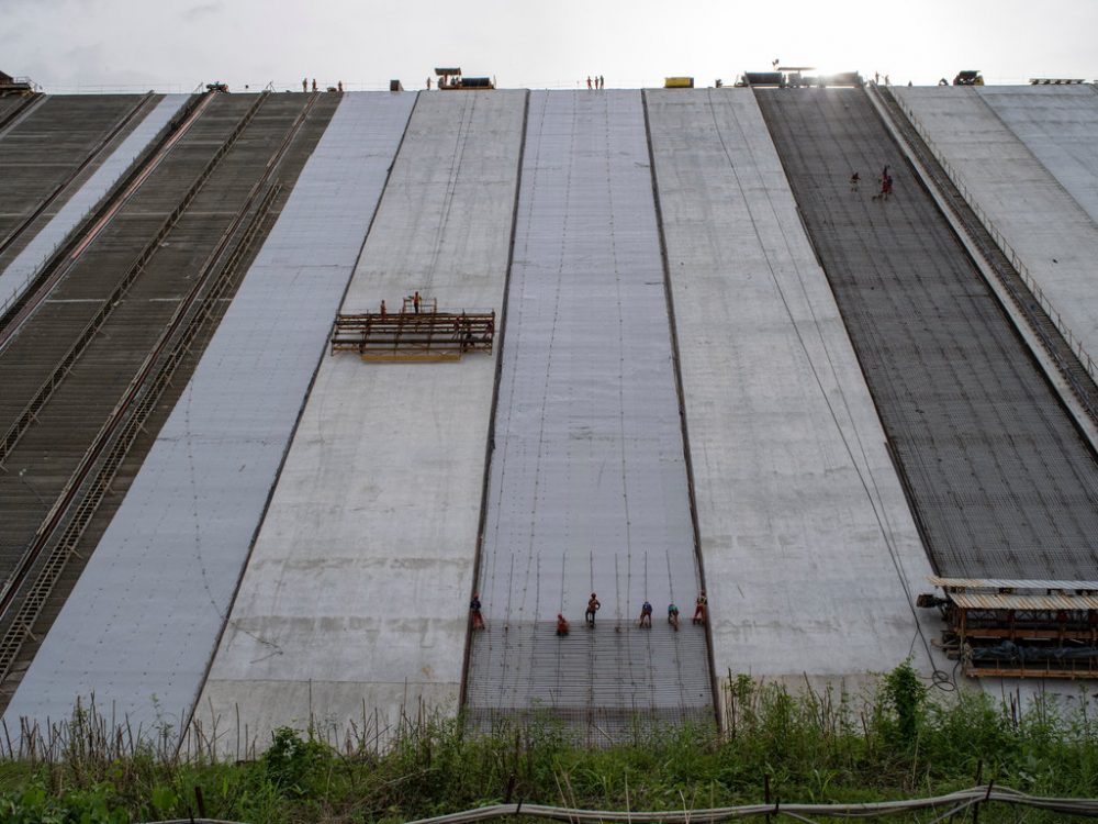
Quando si parla di dighe, si pensa all’Olanda. Ma le dighe sono motori per l’economia, ovunque ci sia acqua. E per l’acqua si litiga di più che per il petrolio così afferma l’Unesco, in un suo recente rapporto. In Etiopia sta per essere completata una diga idroelettrica sul fiume Nilo a più di 3000 metri di altezza. Nella prossima estate, si potrà cominciare a riempire il bacino. La diga è molto importante per l’economia etiope. Ma l’opera minaccia di ridurre ulteriormente l’approvvigionamento idrico dell’Egitto, paese desertico e per lo più abitato proprio sulle sponde del fiume.
GRAND RENAISSANCE DAM ON THE NILEStudio Pietrangeli, Salini Costruttori #progetto #costruzione #tempodacqua #thetimeofwater
When we talk about dams, we think of Holland. But dams are engines for the economy, wherever there is water. And for water there is more controversy than for oil, so says UNESCO in a recent report. In Ethiopia, a hydroelectric dam on the Nile river, more than 3000 meters high, is nearing completion. In the next summer, it will be possible to start filling the basin. The dam is very important for the Ethiopian economy. But the work threatens to further reduce the water supply of Egypt, a desert country and mostly inhabited right on the banks of the river.
The Grand Ethiopian Renaissance Dam project, currently under construction in Ethiopia, is located approximately 40 km downstream of the confluence with the River Beles at a narrow point about 15 km upstream of the Ethiopian border with Sudan. The main dam is a roller compacted concrete (RCC) gravity dam with a maximum height of 175 m and a length of about 2 km at crest elevation, reaching a total volume of about 10 million m3.
Mazatlán Aquarium e mostra di Tatiana Bilbao a Copenhagen — Bilbao’s work on show in Copenhagen
A Copenhagen, in Danimarca, è in corso una retrospettiva di Tatiana Bilbao. L’architetto ha di recente affermato, in un’intervista a Deezen, la sua decisa posizione in contrasto all’isteria da rendering, preferendo il valore del disegno e dei collages che lasciano spazio all’immaginazione e alla condivisione. La mostra si svolge nella città di Biarke Ingels, che ha fatto proprio della visualizzazione dei progetti una nuova formula di comunicazione dell’architettura ( TeD del 2009).
The work of Mexican architect Tatiana Bilbao is on show at the Louisiana Museum in Denmark, in an exhibition that includes an imaginary city, a cabinet of curiosities and four full-size architectural mockups. Bilbao operates with closeness and the personal encounter, an approach which can nevertheless end in a major project in a megapolis in Mexico. The exhibition takes place in Copenhagen, the city of Biarke Ingels, BIG, the famous archistar who uses renderings as a form of communication, while Bilbao prefers to use drawings and collages.
Tatiana Bilabao has revealed visuals of a major new aquarium she is building on the Mexican coastline, which is designed to look like a ruin or a shipwreck. The building is planned as an open grid, which will loosely divide the aquarium’s interior into different sections. Each area will be assigned to a different type of marine ecosystem: open sea, coast, land and forest.The building will have monumental concrete walls, draped with indigenous plants and vines. Some of these walls will extend beyond the building volume, which will reinforce the idea of the building as a ruin (in deezen).
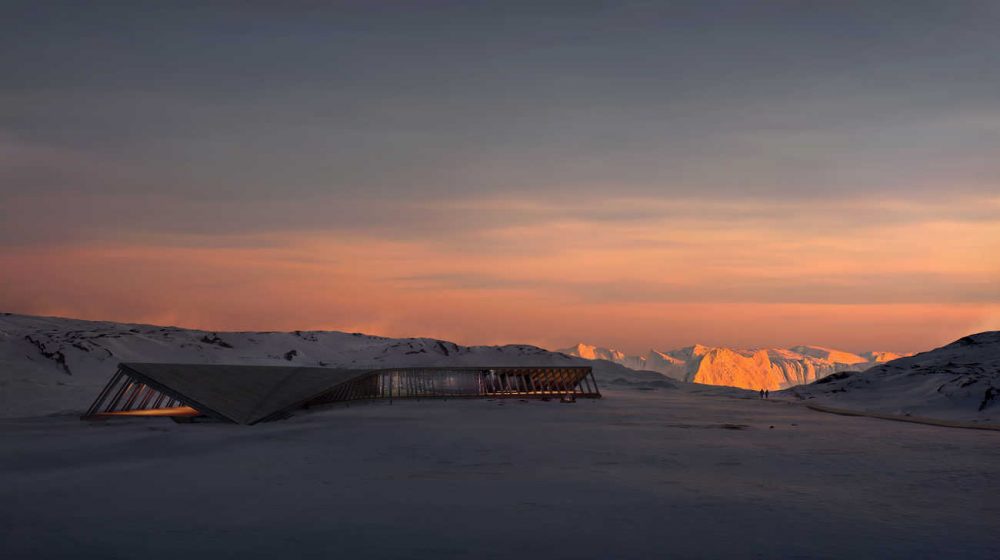
Icefjord centre in Groelandia — Climate change’s last border
Sulla costa occidentale della Groenlandia si trova il massiccio ghiacciaio Sermeq Kujalleq nei pressi del quale Dorte Mandrup ha progettato il nuovo Icefjord Centre di Ilulissat. Il cantiere ha visto la luce nell’estate del 2019 e sarà un osservatorio privilegiato per gli studiosi del cambiamento climatico.
At the western coast of Greenland lies the massive glacier Sermeq Kujalleq. For more than 250 years, glaciologists have studied the ancient glacier and its daily production of immense amounts of ice, and it remains an ideal spot for scientific observation of climate change. Dorte Mandrup has designed the new Icefjord Centre in Ilulissat to blend in with the impressive landscape while offering local residents, tourists, and climate researchers the ultimate vantage point from which to absorb the historic atmosphere of the Icefjord. The Icefjord Centre will tell a story of ice, of human history and evolution on both a local and global scale.
Originating from a background in sculpture and ceramics, Dorte Mandrup’s approach to architecture has always been ‘hands on’. Shape and form constitute the company ethos – to create spaces which are aesthetically pleasing, contextually relevant, and invite people to engage.
Dorte Mandrup graduated from the Aarhus School of Architecture, Denmark in 1991. She founded her Copenhagen based studio in 1999 where she continues to be Creative Director. Her design philosophy and artistic yet systematic mindset permeates the entire office as she is design responsible in all projects.
")
")